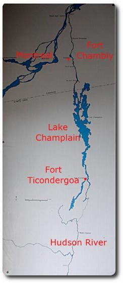
The image at right shows a map of this area, specifically showing the connection from the Hudson River (which ultimately flows past New York City), through Lake Champlain across the border via the Richelieu River into Canada. As such, this has been a trading route for a very long time, predating the arrival of Europeans in the early 1600s.
The history is long, and will not be enumerated here, but a more complete version is available from the Fort Chambly park's web site. Champlain first explored this area in 1609, after consolidating ties with the Montagnais, Algonquin and Huron Indians during a raid against the Iroquois. He paddled up the Richelieu River (then the Iroquois River), noted the rapids at Chambly, and went on to discover and name Lake Champlain (in current day New York state).
The first fort here was a wooden one, built under the direction of Jacques de Chambly, in August 1665, for protection against the Iroquois. There was to be a series of five forts all the way to Lake Champlain. The second wooden fort at Chambly was built in 1690, mainly to replace the detiorating original. The third fort was built in 1702 when an accidental fire destroyed the existing one. The third fort also had a new enemy, albeit an old one of France - the British!
The fourth fort was built of stone in 1709. However, the British attack never came, so it's unknown how well it would have defended against the invaders. It was only able to resist light artillery, as the French concluded that the rapids would prevent heavy artillery from reaching the area.
Also note Fort Ticonderoga. This played a part in the US War of Independence. In 1758, this fort was used by the French to hold back the British, being situated in such a way as to control the south end of Lake Champlain, and thus preventing the British establishing a base in the area.
On May 10th, 1775, the fort was captured by a small force of Americans, under command of Ethan Allen and Benedict Arnold, defeating the unsuspecting British garrison of 22 men! During the winter of 1775/6, the guns and powder were hauled off to Boston to support the siege (against the British), and eventually forcing them to abandon Boston via the sea.
In 1776, the British returned from Canada, but were delayed by American gunboats until winter was imminent. In 1777 the attack resumed, but the British hauled cannon to the top of a nearby mountain, thus threatening the fort. The Americans abandoned the fort, withdrew across the lake and retreated south to the Hudson in disarray. Further details of this are available from Wikipedia, with details of the battle (to take the fort) also available there.
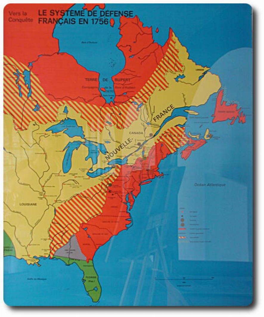
The map above shows the "ownership" of land in North America in 1756. Unfortunately I didn't to take a better photo of the legend, so I am guessing about some of this. The plain yellow would appear to be the area claimed by France. I would expect the red (the traditional colour) to be British claimed territory. Remember this is before the American Revolution. Green I would guess to be Spanish. Yellow and red stripes is perhaps contested territory. The British were clearly in control at the southern end of Lake Champlain, and from there would have staged raids into French territory. In 1760 they took Fort Chambly after capturing the forts along the Richelieu River. On September 8th, 1760, New France capitulated. The Seven Years War (of which this encounter was but part) concluded with the treaty of Paris in 1763. The terms of this treaty handed most French possessions in North America to the British.
But not the southern areas on the left of the map. The treaty ceded western Louisiana and New Orleans to Spain, and eastern Louisiana to the British. Louisiana remained Spanish from 1762 until 1802, when Louisiana returned to France. Napoleon then sold most of the area between the Mississippi and the Rocky Mountains for $US15 million. The Louisiana Purchase amounted to about one third of the current continental US territory.